 Current
Location:
Current
Location: +86 17853698681
 WhatsApp
 Product Details
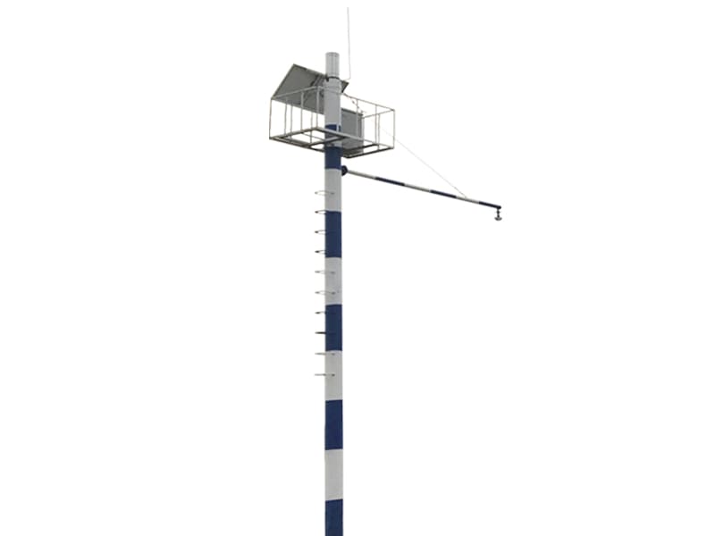
Product Introduction:
The HM-SW2 online automatic radar water level and rainfall monitoring system is a high-precision surface water level measurement and rainfall monitoring system with water surface fluctuation filtering processing. It adopts a horn antenna design to reduce power consumption and a wide range of input voltage, specifically designed for unmanned outdoor automatic station applications. The measurement is not affected by atmospheric temperature, pressure, air density, wind, precipitation, and relative humidity, and has extremely high stability. Low power consumption and maintenance free design. The product has flexible working mode configuration.
The superiority of radar measurement principle makes it suitable for the following working environments: water level monitoring in lakes, rivers, reservoirs, open channels, wetlands, tidal water levels, water level monitoring in areas where water quality is prone to changes, ditches and channels containing large amounts of floating and sediment, places producing large amounts of water and grass, solar power supply, remote field work, and areas with frequent mountain floods.
Basic principle:
The radar pulse is emitted from the radar water level sensor antenna, which receives the reflected pulse from the water surface and records the time (T). As the propagation speed (C) of electromagnetic waves is a constant, the distance to the water surface (D) is obtained. The time from emission to reception of electromagnetic waves is directly proportional to the distance to the water surface, and nanosecond level time measurement is converted into millisecond level time measurement, greatly improving measurement accuracy.
Measurements are taken 55 times per second, followed by digital filtering to minimize the impact of water waves on the measurement results. The measurement results are equivalent to static water level measurements.
Characteristics of monitoring platform:
1. Can store and query historical data; Can save historical data for more than 5 years,
2. The data collection cycle can be set by oneself, and can be collected every minute or every 10 minutes as needed
3. The query results can be converted (table, curve, bar chart);
4. Simultaneously equipped with data import and export function (Excel);
5. At the same time, it can display multi-point water level record data and wirelessly transmit data nationwide.
Function Introduction:
The water level collection instrument has functions such as water level and rainfall data collection, real-time clock, timed storage, parameter setting, and power-off protection for historical parameter data
Standard RS232/485 communication function, supporting MODBUS communication protocol, 4G wireless remote communication method and monitoring platform to form a monitoring system.
There are various power supply methods for the power system, including mains, DC, and solar systems.
Characteristics of HM-SW03 Online Automatic Radar Water Level and Rainfall Monitoring System
Reliable operation in various harsh outdoor environments, low power consumption, high stability, high accuracy, and unmanned operation.
Comprehensive protective measures such as lightning protection and anti-interference.
Both hardware and software adopt modular and open design, which can be flexibly combined and used.
Communication methods can be selected according to needs.
Adopting a field protection box, it has a beautiful appearance, corrosion resistance, and anti-interference ability.
System features:
Not affected by atmospheric temperature, pressure, air density, wind, rainfall, and relative humidity;
Not affected by water pollutants and sediments;
Not affected by changes in water quality;
No need for anti wave wells, no impact on water flow;
The measurement accuracy can reach millimeter level;
The measurement range can reach 30 meters;
Continuous online collection, powered by solar energy;
Non contact measurement method, unaffected by floating debris;
Low maintenance cost, simple installation and maintenance, and long service life;
Main technical parameters:
Range: 30m;
Measurement accuracy:± 1-2mm;
Antenna material: stainless steel 316L horn/PTFE oscillator;
Antenna structure: pointed conical oscillator;
Frequency range: 26GHz;
Signal output: RS485/MODBUS protocol;
Power supply: (6-26) V DC
Process connection: G1/2 thread or 11/2 NPT
Medium temperature: -40-120 ℃
Process pressure: -1.0-3bar
Repeatability:± 2mm
Accuracy:<0.1%
Frequency range: 26GHz
Explosion proof/protection level: Exia II CT6/IP67
There are 5 types of radar water level scoring, namely: measurable distance of 30 meters, measurable distance of 25 meters, measurable distance of 15 meters, measurable distance of 10 meters, and measurable distance of 5 meters.
After sales service:
Service and after-sales introduction
Our company provides a two-year free warranty service for the entire machine; Within two years, all accessories will be replaced without repair, providing lifelong machine maintenance, and providing cost price accessories within five years. After receiving the repair notice, our company should promptly dispatch technical personnel for repair.
- Previous: no more
- Next: no more
 Related Products